Immediately after getting TouCans back on the air a few days back, I was presented with the opportunity to see a few things about how the rig works and whether or not its antenna angle might be an issue.
W6CSN shared a post about his POTA outing with his KH-1 on the same day. I inquired as to the power he used. He replied that he was running 4 Watts into his EFHW antenna from San Pablo Bay National Wildlife Refuge, US-0212.
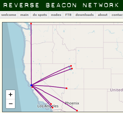
I have, for a long time, wanted to find out if the Rocky Mountains barrier faced by TouCans during the day is a feature of the rig, the ionospher, or the rig's antenna angle, (sloping down a hill in the backyard.) Based on Matt's QSO report and RBN spots vs. my RBN spots for the day, it looks like the barrier might be an ionosphere thing:
Notice the cutoff with no QSOs past Utah and Arizona. That's what I saw during the same day for TouCans on the RBN:
Here, you can see that only one spot made it out as far as as th Kansas/Missouri border. Also note that the rig was spotted at 34 dB, (34 dB into anywhere is a hefty signal for TouCans), in LA which fits with W6CSN remarking about his unusal QSOs to the South.
The ionospheric causation idea holds up looking at W6CSN's RBN spots for the same day 24/09/02:
Of course, as with all things ionosphere and HF, I don't have a conculsive answer, there are too many variables. I'm going to go down a not strictly robust path here and say that the difference in antenna types, (kinda vertical EFHW vs. dipole), and sites, (plain at sea level at San Pablo Bay vs. hillside in SF proper a few miles to the South), make the ionosphere on the 2nd more of a likely culprit for the similar results.
Why was the ionosphere doing the things it did? I don't know yet, but I'll keep you posted.


In addition to antenna configuration, I wonder how the shape of the Bay influences the propagation of signals. From the San Pablo Bay NWR you have 60 miles of salt water oriented SSE, favorable for a single hop to SoCal on 14MHz?
ReplyDeleteWhen operating from East Beach in the Presidio of SF, the bodies of salt water are oriented east through north, which is also where the QSO are generally from. Although at East Beach, I typically use a vertical antenna.
de W6CSN
That's an interesting question! Our backyard station is about three miles due West of Avisadero Point, so it seems squarely inland, but the water we can see runs pretty much uniformly Nort-South both to the East of us (the Bay), and to the West, (the Pacific Ocean about 4 miles off.) I've got to look at some data when we were closer to the water with TouCans. Cool!
ReplyDeleteI started playing with VOACAP in an effort to understand how propagation on various bands varies with time of day from the parks I activate here in CN97. It was an eye opening experience. In particular I commend to you the 'reliability map' feature, which makes it easy to visual what your signal footprint will look like. You can change time of day. You can change season. Fiddle around enough and you start to get a feel for things, including how large the skip zone will be and so on. I'm not saying it make me an expert on these things but I will claim it made me significantly less clueless. www.voacap.com.
ReplyDeleteThanks Paul! It VOACAP looks pretty cool. Now I just need to carve out the time to learn how to use it :)
ReplyDelete