
Ground Wave Propagation and Ground Wave Moisture

 Everything I learned today centers around a question I still haven't learned the answer to. Can we use groudn wave propagation SnR data between San Francisco, Berkeley, and Stanford to measure soil moisture?


I noticed that the SNR (signal to noise ratio) as measured  by the RBN (reverse beacon network) spotting stations went up after we started routinely getting rain last week. First, let's get some data to support what I'm saying. The stations are W6YX, (located in Stanford), W6BB, (located in Berkeley), and NU6XB, (also located in Berkeley). Using Datasette to look at the SNR levels from the three stations for the last three weeks gives


The top two charts, W6BB and W6YX show some trends. The chart for NU6XB, at first glance, actually seems to disprove that the increased ground water had anything to do with better SNR.

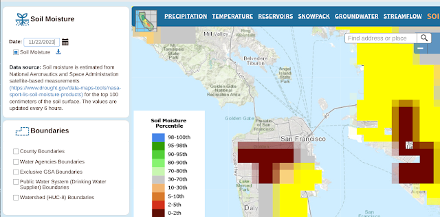
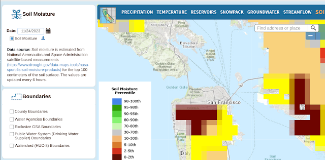
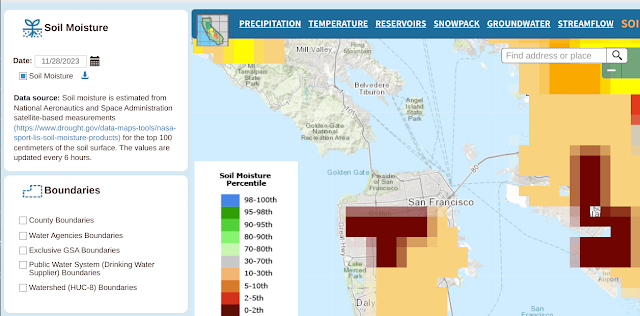
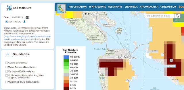
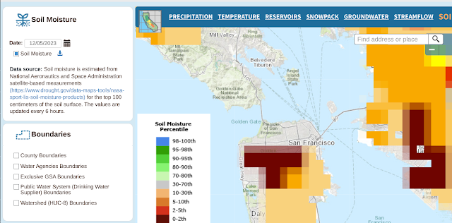
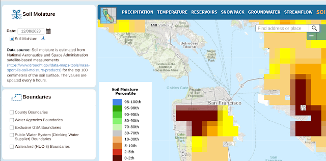
In any event, here's the ground moisture data captured over the same time span.
Moisture data 11/22
PMoisture data 11/22
Moisture data 11/23
PMoisture data 11/23
Moisture data 11/24
PMoisture data 11/24
Moisture data 11/25
PMoisture data 11/25
Moisture data 11/26
PMoisture data 11/26
Moisture data 11/27
PMoisture data 11/27
Moisture data 11/28
PMoisture data 11/28
Moisture data 11/29
PMoisture data 11/29
Moisture data 11/30
PMoisture data 11/30
Moisture data 12/01
PMoisture data 12/02
Moisture data 12/03
PMoisture data 12/03
Moisture data 11/22
PMoisture data 12/03
Moisture data 12/04
PMoisture data 12/04
Moisture data 12/05
PMoisture data 12/05
Moisture data 12/06
PMoisture data 12/06
Moisture data 12/07
PMoisture data 12/07
Moisture data 12/08
PMoisture data 12/08


And here are the many, many links to things the gang and I should learn to do more with this:

The important bit: our code so far

The Google Earth Engine REST API so maybe this can all be done in Python

Looks like we'll be using Google Earth Engine, but here's how to rad hf files.

Here's where to get L2 data.

Fundamentals of remote sensing

Soil moisture training

Visualizing ImageCollections

Using Google Earth to visualize soil moisture

The smap L4 layer

It looks like maybe we can get more realtime-ish data by analyzing our own h5 files. Here's a link to the Python script for that. It's pointed to from this page.


Here's how to use something called the Data Access Manger. The pointer came from this rather obscure location.


Comments

Popular posts from this blog

More Cowbell! Record Production using Google Forms and Charts

First, the what : This article shows how to embed a new Google Form into any web page. To demonstrate ths, a chart and form that allow blog readers to control the recording levels of each instrument in Blue Oyster Cult's "(Don't Fear) The Reaper" is used. HTML code from the Google version of the form included on this page is shown and the parts that need to be modified are highlighted. Next, the why : Google recently released an e-mail form feature that allows users of Google Documents to create an e-mail a form that automatically places each user's input into an associated spreadsheet. As it turns out, with a little bit of work, the forms that are created by Google Docs can be embedded into any web page. Now, The Goods: Click on the instrument you want turned up, click the submit button and then refresh the page. Through the magic of Google Forms as soon as you click on submit and refresh this web page, the data chart will update immediately. Turn up the:

Cool Math Tricks: Deriving the Divergence, (Del or Nabla) into New (Cylindrical) Coordinate Systems

Now available as a Kindle ebook for 99 cents ! Get a spiffy ebook, and fund more physics The following is a pretty lengthy procedure, but converting the divergence, (nabla, del) operator between coordinate systems comes up pretty often. While there are tables for converting between common coordinate systems , there seem to be fewer explanations of the procedure for deriving the conversion, so here goes! What do we actually want? To convert the Cartesian nabla to the nabla for another coordinate system, say… cylindrical coordinates. What we’ll need: 1. The Cartesian Nabla: 2. A set of equations relating the Cartesian coordinates to cylindrical coordinates: 3. A set of equations relating the Cartesian basis vectors to the basis vectors of the new coordinate system: How to do it: Use the chain rule for differentiation to convert the derivatives with respect to the Cartesian variables to derivatives with respect to the cylindrical variables. The chain

The Valentine's Day Magnetic Monopole

There's an assymetry to the form of the two Maxwell's equations shown in picture 1.  While the divergence of the electric field is proportional to the electric charge density at a given point, the divergence of the magnetic field is equal to zero.  This is typically explained in the following way.  While we know that electrons, the fundamental electric charge carriers exist, evidence seems to indicate that magnetic monopoles, the particles that would carry magnetic 'charge', either don't exist, or, the energies required to create them are so high that they are exceedingly rare.  That doesn't stop us from looking for them though! Keeping with the theme of Fairbank[1] and his academic progeny over the semester break, today's post is about the discovery of a magnetic monopole candidate event by one of the Fairbank's graduate students, Blas Cabrera[2].  Cabrera was utilizing a loop type of magnetic monopole detector.  Its operation is in concept very sim