Reading W6CSN's post on his recent POTA at Mt. Tamlpais got me thinking. How many QSOs had I made from the region, and had I sent out QSLs for all of them, and had I updated our log database to reflect those QSLs?
Actually Doing the Thing
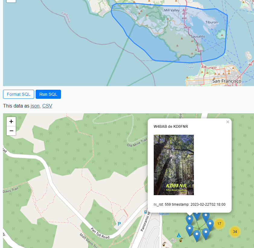
So, I wanted to be able to display a map, draw a region on the map, and then review the QSOs I'd made from that region. Armed with a map of QSOs, I also wanted to be able to click each QSO to see if I'd updated the QSL photo for the occasion in our QSO database.
After working though the issues I discuss below, I was delighted to be able to search for our QSOs from the Pantoll Campground Region like so:
Now that we've seen the end result, here are the issues I ran into getting everything set up.
Install the Plugin(s)
To do the things I'm about to talk about, you'll need Datasette and a few plugins.
There was an issue using Datasette with Spatialite on Windows for me. I got around it though.
How DOES one get a geometry object?
When calling MakePoint be sure to cast your coordinates to floating point first, like so
MakePoint(cast(longitude as float), cast(latitude as float))Otherwise, there's an error message for that.
Longitude and Latitude Work. Hierarchical Table References? Not so much.
In an early version of the SQL query, I'd tried to play nicely by using the full names of table fields. This did not work, (meaning 0 rows were returned for the query.) I do not know why yet. However, while working with Diaze—the 12 year-old here who's learning Python—I used the 'as' names of the columns instead, completely expecting them not to work either, but hoping for a more informative error message. Instead, the query just worked. So, this won't work for me:
select rm_rnb_history_pres.tx_lng as longitude , rm_rnb_history_pres.tx_lat as latitude, rm_rnb_history_pres.timestamp, rm_rnb_history_pres.dB, rm_rnb_history_pres.Spotter, rm_rnb_history_pres.QSL_link, photo_path.path, photo_path.uuid, json_object(

        'image',

        '/-/media/thumbnail/' || uuid,

        'title', Spotter || ' de KD0FNR',

        'description', 'rx_rst: ' || dB || '  timestamp: ' || rm_rnb_history_pres.timestamp

    ) as popup from rm_rnb_history_pres LEFT JOIN photo_path ON rm_rnb_history_pres.QSL_link = photo_path.uuid where db > 100 and
Intersects(GeomFromGeoJSON(:freedraw), MakePoint(cast(rm_rnb_history_pres.tx_lng as float), cast(rm_rnb_history_pres.tx_lat as float))) = 1  order by
rm_rnb_history_pres.timestamp asc
but this totally did:
select rm_rnb_history_pres.tx_lng as longitude , rm_rnb_history_pres.tx_lat as latitude, rm_rnb_history_pres.timestamp, rm_rnb_history_pres.dB, rm_rnb_history_pres.Spotter, rm_rnb_history_pres.QSL_link, photo_path.path, photo_path.uuid, json_object(

        'image',

        '/-/media/thumbnail/' || uuid,

        'title', Spotter || ' de KD0FNR',

        'description', 'rx_rst: ' || dB || '  timestamp: ' || rm_rnb_history_pres.timestamp

    ) as popup from rm_rnb_history_pres LEFT JOIN photo_path ON rm_rnb_history_pres.QSL_link = photo_path.uuid where db > 100 and
Intersects(GeomFromGeoJSON(:freedraw), MakePoint(cast(longitude), cast(latitude))) = 1  order by
rm_rnb_history_pres.timestamp asc
Do you have to have a column named geometry?
You do not have to have a column named geometry if you have a parameter named freedraw, that's enough to get the plugin to load the drawable map. The documentation mentions this, but I wasn't clear on the distinction at first, so I'd also added a column named geometry with the MakePoint call. I later removed the column and everything was fine.
You can only display images if you have the image query loaded in as metadata
On my first try, all the image links were broken. Then I remembered to load the metadata.json file from my project, and everything was just fine. My command line wound up being
python -m datasette rm_toucans_23_10_23.db --metadata metadata.json --load-extension=SpatiaLiteReferences:
W6CSN's POTA post that inspired all this
Comments
Post a Comment
Please leave your comments on this topic: